California faces heightened risk of megafloods
Frequency of catastrophic deluges increases with climate change
Aug 15, 2022 - by David Hosansky
Temporary impacts to NSF NCAR Road, Parking Lot and Trails
View more information.Aug 15, 2022 - by David Hosansky
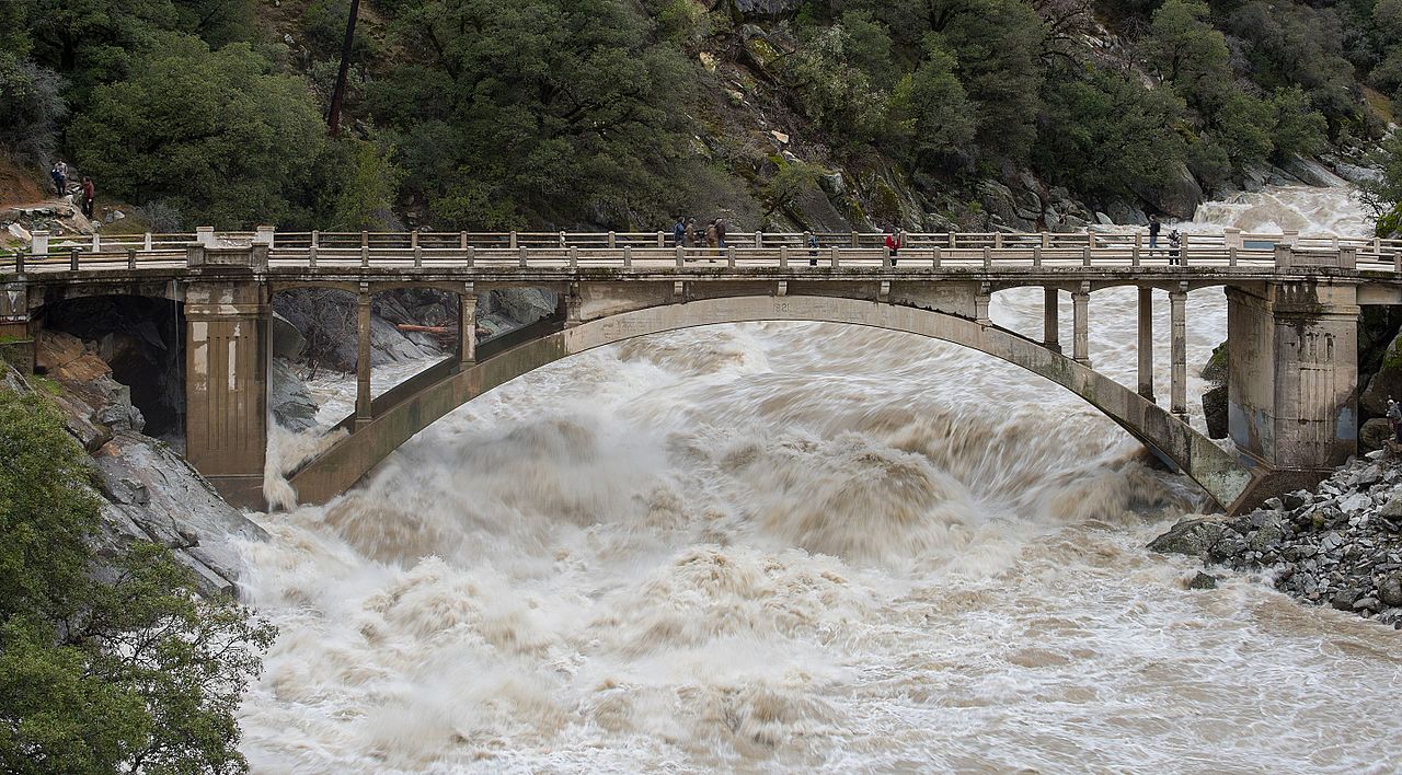
The South Yuba River at Highway 49 during 2017 floods that would ultimately cause 5 deaths and more than $1.5 billion in damage. A historic megaflood, which may become more frequent with climate change, would be far more catastrophic. (Kelly M. Grow, California Department of Water Resources.)
Although California is currently contending with historic drought, a new study indicates that climate change is sharply increasing the risk of a catastrophic megaflood that could submerge large swaths of the state and displace millions of residents.
The study by scientists at the National Center for Atmospheric Research (NCAR) finds that the likelihood of such a calamitous flood has already doubled because of climate change. If society were to follow a worst-case climate scenario of emitting greenhouse gasses at a high rate, the state by later this century could expect to experience a catastrophic megaflood about every 30-35 years, instead of just once in two centuries.
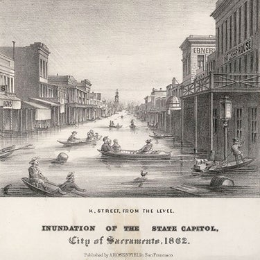
The last time such an event hit California, in 1861-62, the deluge of water transformed much of the state into an inland sea, killing 1% of the population and resulting in devastating economic losses.
“The megaflood risk with climate change is much greater than we expected,” said NCAR scientist Xingying Huang, the co-lead author of the study. “These types of extreme events are rare, but they will happen, as predicted, with more frequency as warming continues.”
The extreme rainfall required to create a megaflood would likely be associated with a series of atmospheric rivers — long and narrow regions in the atmosphere that are a critical source of cool-season moisture on the West Coast. Previous research has shown that climate change is altering the intensity and path of atmospheric rivers. The authors used a combination of advanced computer models to detail how these changes will affect extreme precipitation and runoff across California.
They found that the state not only faces the threat of more intense winter precipitation but also disproportionately greater volumes of runoff. That is partly because more precipitation will fall as rain instead of snow, thereby immediately rushing down slopes instead of slowly melting into the soil.
"Although California has recently experienced historically severe drought and the broader Southwest is facing an accelerating water scarcity crisis, it's important to remember that this is still a region susceptible to rare but potentially severe floods,” said co-lead author Daniel Swain, a University of California, Los Angeles scientist who is also affiliated with NCAR and The Nature Conservancy. “It may seem paradoxical that climate change is increasing the risks associated with both droughts and floods in a place like California, but that's exactly what the scientific evidence suggests."
The study emphasizes that the state can take steps to mitigate the impacts of a megaflood. It also finds that the probability of a catastrophic flood might be predictable because the risk is much higher in years when there is a warming of surface waters in parts of the tropical Pacific Ocean, a phenomenon known as El Niño.
Although the scientists focused on California, Huang said the findings could hint at greater risks for other regions along the West Coast and elsewhere that receive substantial precipitation from atmospheric rivers.
The study, published last week in Science Advances, was funded by the Yuba Water Agency and the California Department of Water Resources, as well as by the U.S. National Science Foundation, which is NCAR’s sponsor. It represents the first phase of a broader project, known as ARkStorm 2.0 project, that involves multiple organizations — including the University of California, U.S. Geological Survey, California Department of Water Resources, Desert Research Institute, and NCAR — to better understand and prepare for the risks of catastrophic floods in a warming climate.
California has faced several severe floods in recent decades, including the so-called New Year’s Day flood of 1997, which damaged more than 20,000 homes and businesses, forced the evacuations of more than 120,000 residents, and left nine people dead. But such events pale compared with megafloods that are estimated to strike about five to seven times every 1,000 years. The last such megaflood, caused by weeks of winter storms in 1861-62, transformed the Sacramento and San Joaquin valleys into a temporary inland sea nearly 300 miles in length and up to 30 feet deep, while inundating much of the coastal plain in what is now the densely populated Los Angeles and Orange counties.
If such an event were to occur now, it would displace millions of people, shut down critical transportation corridors, and ultimately lead to nearly $1 trillion in economic losses, according to estimates by the U.S. Geological Survey.
To examine how climate change may affect such floods, Huang and Swain coupled two powerful computer models: the NCAR-based Community Earth System Model, which simulates global climate, and the NCAR-based Weather and Research Forecasting Model, which simulates regional weather events at high resolutions. They simulated multi-week storms similar to those that triggered the 1861-62 flood, comparing the resulting impacts in a climate that existed from 1996 to 2005 with a hypothetical warmer climate from 2071-2080 that would occur if society continues to pump greenhouse gasses into the atmosphere at a high rate (a scenario known as RCP 8.5).
They performed the simulations on the Cheyenne supercomputer at the NCAR-Wyoming Supercomputing Center.
In both scenarios, the storms unleashed torrential amounts of precipitation across widespread regions, totaling about 20-40 inches in the 1996-2005 period and up to about 55 inches in the future scenario. Parts of the Sierra Nevada faced even greater deluges: 60-70 inches in the 1996-2005 period and as much as 100 inches in the future.
"Imagine the wettest storms you can remember in your lifetime. Then imagine they all came back to back, in quick succession, over the course of a month,” Swain said. “That's essentially our historical scenario. Add a couple of additional storms that are worse than anything you can remember in your lifetime, and that's equivalent to our future scenario."
The peak runoff in the future scenario was up to five times that of 1996-2005, which was the result of greater precipitation rates and of rain, rather than snow, falling at all but the very highest elevations. In addition to steep hillsides, runoff was high in major urban areas with impervious, paved surfaces, raising the specter of urban flooding.
The research showed that every degree of warming increases the risk. Already, the annual likelihood of a megaflood is about twice as high as 1920, when the climate was cooler. By 2060, on a high emissions trajectory, the likelihood of a megaflood occurring in any particular year will be roughly 4-7 times more than a century ago. Even if the international community were to meet the goals of the Paris Agreement, which aims to hold warming to no more than about 2°C, the risk of a California megaflood would be substantially greater than today.
The study emphasizes that the state can take steps to mitigate flood impacts through such strategies as floodplain restoration and levee setbacks, greater flexibility in reservoir operations, and revised evacuation and contingency plans in the case of a flood.
“Our hope is that this type of analysis can help guide adaptation measures in different parts of the state,” Huang said.