50 years of falling
NSF NCAR dropsondes have been providing essential atmospheric observations since 1974
Oct 15, 2024 - by Laura Snider
Oct 15, 2024 - by Laura Snider
Fifty years ago this fall, atmospheric researchers from across the globe were wrapping up the largest and most ambitious atmospheric research field campaign that had been executed to date, known as GATE — or more formally, the Global Atmospheric Research Program’s Atlantic Tropical Experiment.
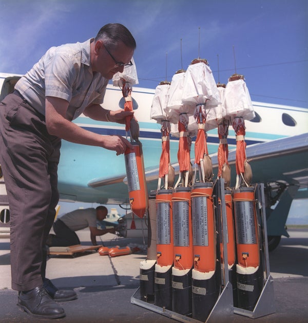
The campaign lasted 100 days and involved more than 5,000 scientists, technicians, and support staff from 72 countries (including approximately 40 staff from the U.S. National Science Foundation National Center for Atmospheric Research, or NSF NCAR) as well as 39 ships and 13 aircraft (including the NSF NCAR Electra). Among GATE’s many legacies is the first use of the modern dropsonde, a tube-shaped instrument package developed at NSF NCAR that is jettisoned out of an aircraft before floating to the ground under a small parachute, collecting data about temperature, humidity, pressure, and wind speed as it falls.
The dropsonde has since become ubiquitous on airborne research and reconnaissance missions, proving time and again the essential value of observations from within extreme weather events to improve both our understanding of their physics and our ability to forecast their evolution, saving lives and livelihoods.
Over the last half century, the NSF NCAR Dropsonde Program has remained the leader in developing dropsonde technology, ensuring that dropsondes continually became more accurate, more affordable, and lighter weight.
“Dropsondes are an amazing success story that highlights the importance of having a national center,” said Holger Vömel, an NSF NCAR senior scientist who works with the Dropsonde Program. “The observations provided by dropsondes have allowed scientists to make giant leaps forward in our understanding of the atmosphere generally and severe weather in particular. This is exactly the kind of work that makes sense for NSF NCAR to take on, and the result has benefited not just researchers, but operational forecasters and society as a whole.”

For centuries, scientists have been interested in how to measure conditions in the atmosphere far above their heads. As early as 1749, Europeans were experimenting with tying a thermometer to a kite to measure the temperature aloft. By the early 1900s, scientists had developed a package of meteorological instruments that could be carried by kites to measure pressure, temperature, and relative humidity. Instruments were also attached to balloons that could rise to greater heights before popping and falling to the ground. But the instruments had to be recovered for the scientists to collect the data, which was frequently a challenge.
In the 1930s, scientists began to attach early radio transmitters to these weather balloons so the data could be broadcast to stations on the ground instead of having to retrieve the instruments. These were the first radiosondes.
Attempts to develop a “droppable radiosonde” — or dropsonde — that could be ejected from an aircraft began in the middle of the 20th century and were undertaken simultaneously at several different labs, some of which were driven by the war effort. In fact the first “parachute radiosonde” was developed in 1943 by the U.S. Army’s Signal Corps Laboratories.
At NSF NCAR, the push to build a dropsonde was driven by the desire to drop an instrument package into a thunderstorm from above, which scientists hoped would give them an unprecedented peek into the heart of the storm. In particular, NSF NCAR scientists were interested in measuring and mapping the vertical winds inside thunderstorms — the updrafts and downdrafts that they believed controlled the quantity of rainfall and lightning. They were especially interested in the conditions that lead to hail formation, which they thought were connected to the strongest updrafts.
NSF NCAR tested its dropsondes for the first time in the summers of 1966 and ‘67, dropping the instruments from the propeller-driven NSF NCAR Queen Air over northeastern Colorado. In 1970 and ‘72, more dropsondes were released, this time by the NSF NCAR Sabreliner research jet, a larger plane with the capability of ejecting the instrument packages from a higher altitude.
As hoped, the dropsondes provided scientists with useful information about vertical winds as they fell, but they lacked the ability to measure horizontal winds. In fact, it was impossible to track the horizontal movement of the dropsonde with any accuracy at all, though the researchers did attempt to note where the plane was when it ejected the dropsondes and where they found them on the ground. So while the dropsondes did provide new insights into updrafts and downdrafts in severe storms that have the potential to produce hail, they were not as useful for broader questions about high-level winds and how they impact the evolution and movement of weather systems.
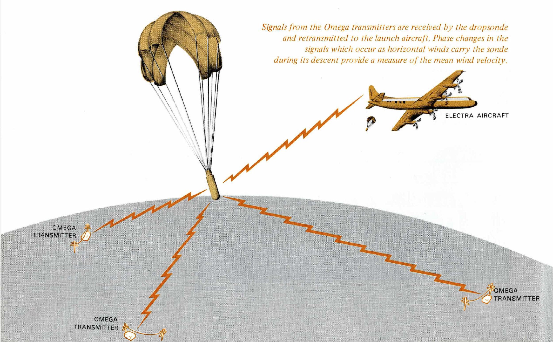
Two large efforts came together to enable the development of a “wind-finding” capability in dropsondes and to launch the modern era of dropsonde use. First, the world’s first global-range radio navigation system, Omega, began to come online around 1971. It allowed ships and aircraft to pinpoint their location by receiving very low frequency radio signals from multiple fixed radio beacons on land. If NSF NCAR scientists and engineers could harness this same technology, then they might similarly be able to pinpoint the location of dropsondes in space, even over the open oceans, where traditional ground-based tracking was not an option.
Secondly, NSF NCAR’s involvement in the 1974 GATE field campaign brought urgency to the quest to develop a dropsonde with wind-finding capabilities. GATE’s scientific objective was to better understand how the atmosphere in the tropics influenced global circulation patterns, and researchers felt that having a way to measure the wind speed and direction over the ocean would be a critical component to their success.
With a deadline set by the GATE campaign and a possible technical solution on the table, NSF NCAR got to work. The result, the Omega-based dropwindsonde (ODW), was ready in time for GATE. Hundreds of dropsondes were used during GATE and they provided the first reliable wind profiles (measurements of how the wind changes as the instrument falls to the Earth’s surface) over the Atlantic ocean. But they had significant limitations, including the fact that their wind-finding capabilities did not work well in clouds or rain and their pressure sensors were sometimes quite unreliable. Still, their utility for the future of atmospheric research was immediately recognized.
“I think the dropwindsonde developed at [NSF] NCAR is one of the really important instrumental developments of recent years,” Robert Simpson, director of NOAA’s National Hurricane Center (NHC), said in the fall of 1974. “Surely it is the route all operational reconnaissance aircraft should go in the future for comprehensive data acquisition.”

Dropsonde use caught on quickly. In 1982, the NHC tested whether dropsondes ejected during reconnaissance missions of Hurricane Debby could improve its track forecast. Finding that dropsondes could provide useful information about the hurricane's steering flow — the winds that push the hurricane toward or away from shore — the program adopted dropsonde use on its hurricane hunters. Similarly, the U.S. Air Force began using dropsondes for their own storm reconnaissance missions.
The additional data provided by the dropsondes brought significant returns. A study published in 1982 analyzing the effectiveness of ejecting dropsondes from hurricane hunting aircraft found that the data improved track forecasts by 20-30%.
Meanwhile, NSF NCAR continued to improve the dropsonde. In 1987, the organization began development of a new dropsonde called the Lightweight, Long-Range Navigation Digital Dropsonde, or L2D2. The instrument package relied on the much more accurate Loran regional navigation system, rather than Omega, and for the first time used digital rather than analog components. It was also less than a third as heavy as the ODW.
A decade later, NSF NCAR scientists were at work on the first dropsondes capable of using GPS satellites for wind-finding. The new system, named the Airborne Vertical Atmospheric Profiling System (AVAPS), debuted in 1996 and is still used today in its 5th generation of GPS dropsondes.
The current AVAPS system is used by NOAA, both on its hurricane hunters as well as on its Gulfstream IV research jet. AVAPS is also used by the hurricane hunters of the U.S. Air Force’s 53rd Weather Reconnaissance squadron. Of course, both of NSF NCAR’s research planes — the C-130 and the Gulfstream-V — are fitted with AVAPS systems, as are research planes belonging to the University of Wyoming, NASA, DLR (the German Aerospace Center), the UK Met Office, and other institutions.
With these resources, scientists continue to find new and sometimes unexpected ways to use dropsondes that are improving our understanding of weather and our ability to forecast severe events.
“The quality of today’s dropsonde observations would not have been dreamt of 50 years ago,” Vömel said. “And dropsondes are now being equipped with the ability to measure new parameters that will help continue pushing the boundaries of atmospheric observations.”
Dropsondes are used in many different studies of our atmosphere, from processes over Arctic sea ice leads to the properties of tropical deep convection and surface layer inversions over the Antarctic continent. They are also used to help us understand fire weather and flooding events in California.
“Dropsondes have become one of the workhorses of atmospheric research, and are now considered an essential part of any airborne research or weather reconnaissance missions,” said NSF NCAR engineer Terry Hock, who developed the GPS dropsonde and continues to be involved in the program. “It’s been an incredibly rewarding experience to see the significant scientific advancements that dropsondes have contributed to. It’s gratifying to know that our work has a significant societal impact in improving forecasts for communities threatened by severe weather.”