Scientists eye hurricanes, rainfall in global high-def
High-resolution simulations aim to improve forecasts of tropical cyclones and rainfall worldwide
Sep 25, 2025 - by David Hosansky
Early closure on July 3 and 4 - NSF NCAR Road, Parking Lot and Trails
View more information.Sep 25, 2025 - by David Hosansky
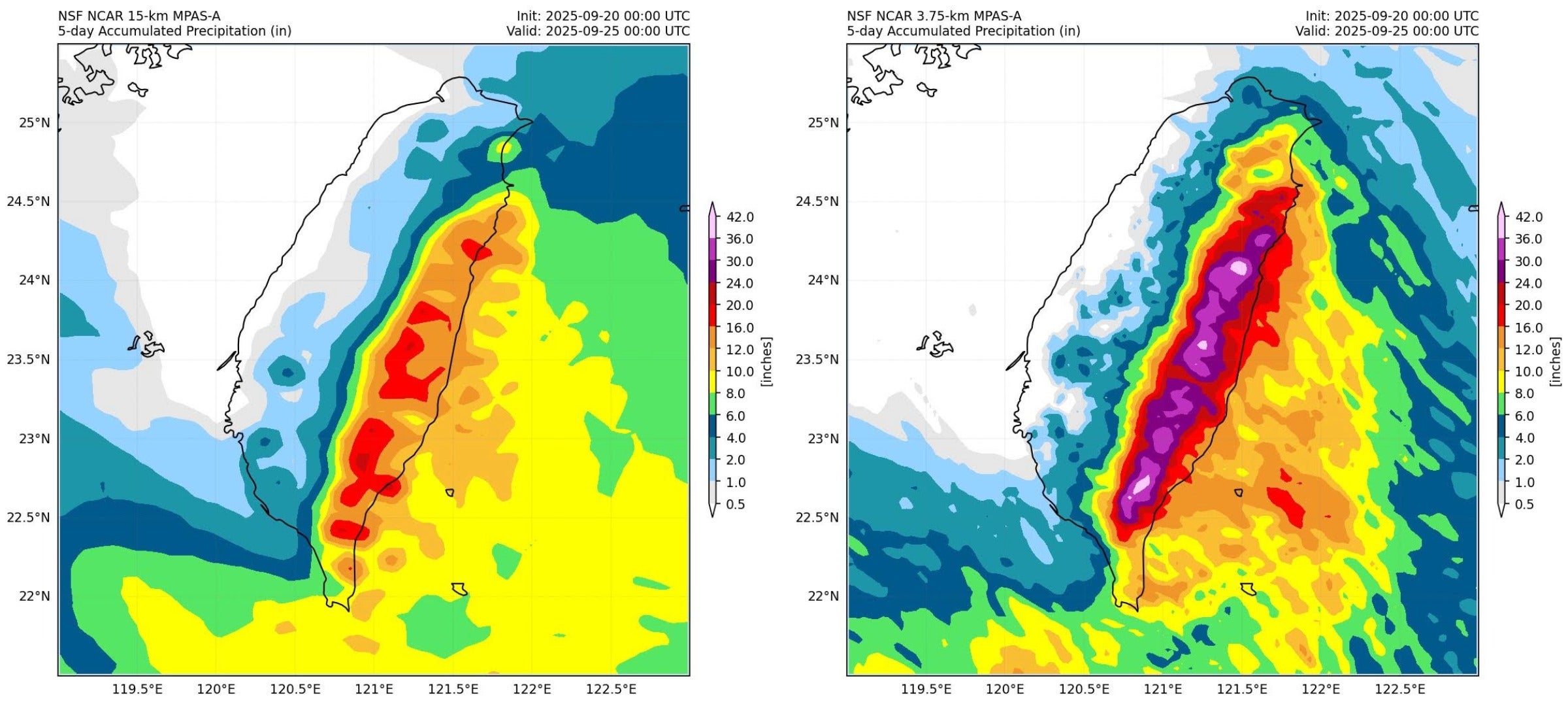
Three days before the outer rainbands of Typhoon Ragasa caused devastating flooding in Taiwan, MPAS simulations captured the event. This case highlights how higher resolution adds value to a forecast: the 3.75-kilometer modeling (right) better captures the stark contrast between extreme upslope rainfall and the near-dry leeward side. In contrast, the 15-kilometer modeling (left) smooths over those details.
| Impact statement: Higher resolution computer models may significantly improve hurricane predictions, enabling advanced notice to agencies and communities. |
Even before thunderstorms over the Pacific Ocean began to significantly build last week, experimental forecasts at the U.S. National Science Foundation National Center for Atmospheric Research (NSF NCAR) showed the emerging weather system intensifying into a super typhoon. And, indeed, the thunderstorms ultimately spawned Super Typhoon Ragasa, whose 165-mile-per-hour winds made it the most powerful storm on Earth so far this year.
Scientists were able to anticipate Ragasa well in advance by using an innovative computer modeling approach that may bring them to the cusp of significantly improving predictions of hurricanes.
The new system produces 3.75-kilometer (2.3-mile) real-time global forecasts, simulating Earth’s atmosphere in unusual detail. Such fine-scale resolution captures thunderstorms worldwide and shows how weather systems hundreds or even thousands of miles away could influence the evolution of storms in the tropics.
“Essentially this brings the weather into high-def all over the globe,” said NSF NCAR Falko Judt, who is leading the effort. “We think this can really make a difference in forecasting extreme events like hurricanes and flash flood producing rainfall on a global scale.”
The real-time, experimental forecasts have been running throughout September, which is historically the peak of Atlantic hurricane season. Because the first part of the month was unusually quiet, Judt has few case studies to show whether the NSF NCAR forecasts can outperform those produced by operational forecast models.
But the early indications are encouraging, with the NSF NCAR approach also doing comparatively well in capturing last weekend’s rapid intensification of Hurricane Gabrielle over the Atlantic.
To make the forecasts, Judt is using an advanced computer model, the NSF NCAR-based Model for Prediction Across Scales (MPAS). He and his colleagues are running it on the Derecho supercomputer at the NSF NCAR-Wyoming Supercomputing Center in Cheyenne. The primary focus of the work, which Judt characterizes as a demonstration project, is to capture hurricanes in the Atlantic and eastern Pacific as well as typhoons in the western Pacific. But the researchers also want to see how it does in capturing extreme rainfall.
Their effort is similar to one that NSF NCAR temporarily launched last spring. In that case, scientists who were mainly interested in extreme weather in the midlatitudes used MPAS for real-time, 3-kilometer experimental forecasts that went out to 60 hours. Since the focus this time includes tropical cyclones — which are larger than most mid-latitude storms and take longer to develop — Judt is running the forecasts out to 120 hours while dialing back the detail to 3.75 kilometers to make them more computationally efficient.
Weather models such as MPAS use a grid system to represent the atmosphere, applying the laws of physics to simulate temperature, humidity, and other properties at selected points. The closer the points are spaced together, the higher the resolution and the greater the potential for accurate forecasts. Other factors, however, also influence accuracy, such as how the model assimilates data from observations to produce the initial representation of the atmosphere that serves as the basis for the forecast.
Computer models used by forecasting centers often simulate the atmosphere with varying resolution. At the National Hurricane Center, for example, which focuses on storms in the Atlantic and Eastern Pacific, hurricanes are simulated at 2 kilometers and the surrounding environment at about 6-8 kilometers. More distant parts of the globe, however, are simulated far more coarsely.
Such an approach by the hurricane center and other forecasters is ideal for shorter-range prediction, Judt said. But simulating the entire globe in high resolution could not only capture storms anywhere they occur but also help better anticipate tropical cyclones before they form, enabling more accurate forecasts that go out 7 to 10 days.
That appears to be what happened with Super Typhoon Ragasa.
“What stands out to me is that MPAS forecasted this system to be a super typhoon even before the storm had formed,” Judt said. “Earlier, in fact, than many operational models would have anticipated, and with better prediction of its intensity.”
He added that this type of effort may also be valuable for training a new generation of artificial intelligence weather models. The high-resolution, high-quality data provided by MPAS would greatly enhance the current AI models that are trained on much coarser data.That is because it provides high-resolution, high-quality data that most current AI models lack, having been trained on much coarser data.