Storm-proven forecasting gets yearlong trial
NCAR's real-time ensemble forecasts available to anyone online
Jun 3, 2015 - by Staff
Temporary impacts to NSF NCAR Road, Parking Lot and Trails
View more information.Jun 3, 2015 - by Staff
June 3, 2015 | Storm-studying scientists have made their next-generation forecasting system available online so the wider weather community can put it to the test. After using the real-time system during short-lived field research campaigns, developers at the National Center for Atmospheric Research (NCAR) are now ready to see how it performs year-round, and they're eager for user feedback.
In April, NCAR scientists began running daily forecasts using the sophisticated system, which has proven its mettle by skillfully predicting the path of early summer storms as they roll across the country's midsection. The new project, which is funded to run through at least mid-June 2016, will allow scientists to see if the forecasts are as adept at predicting weather phenomena that more frequently occur at other times of the year.
"This type of system has never been run year round," said NCAR scientist Craig Schwartz, who co-leads the project. "We want to examine a wide range of weather phenomena, like winter storms, that are not typically studied with high-resolution models and see how the system performs."
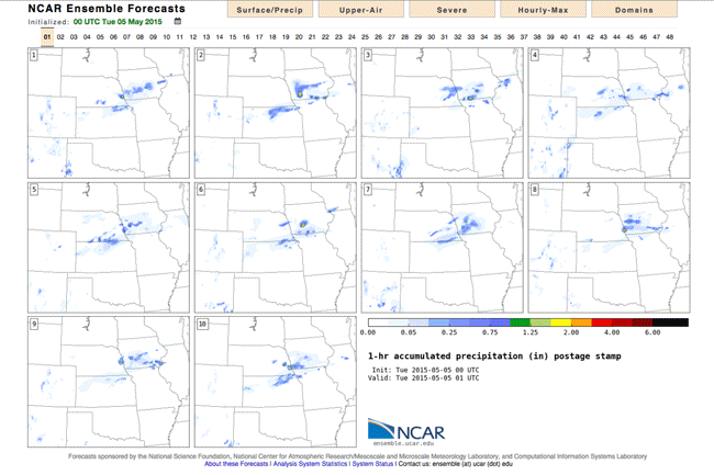
NCAR's high-resolution ensemble forecasts show 10 possible scnearios for how much precipitation was expected to fall acrosss the central Great Plains over a two-day period in early May. Check out current forecasts at ensemble.ucar.edu. (©UCAR. This animation is freely available for media & nonprofit use.)
The high-resolution forecasting system was first developed to aid field scientists trying to get up-close views of severe weather events. Detailed information about where an individual storm is likely headed helps ensure that ground- and air-based observing equipment gets deployed to the best locations.
"We found that the forecasts did a really good job of showing us where the greatest hazards were going to be and allowed us to put field crews in the right places," said NCAR scientist Glen Romine, who has been involved in running the forecasts for past field campaigns.
Now Romine and Schwartz, along with NCAR's Kate Fossell and Ryan Sobash, are extending the forecasts beyond the field, across the country and onto the Internet. By making their forecasts for the continental United States easily available at ensemble.ucar.edu, they hope to get feedback from the meteorological community and hear from scientists who may want to use the data in their own research.
The NCAR team is also supplying the forecasts to the National Severe Storms Laboratory and the Storm Prediction Center, both part of the National Oceanic and Atmospheric Administration. Scientists there are interested in seeing if the data can help them better track individual storms and issue more precise severe weather forecasts.
To predict the path of an individual storm—instead of the general area where conditions are ripe for storm formation—scientists need a weather model that can run at a higher resolution than is commonly used.
Because these detail-oriented models burn through so much computing power, they're typically used to create just a single, deterministic forecast. Deterministic forecasts describe just one possible future weather scenario—a single path that a storm might follow, for example. Because of this, the forecast is either right or wrong; there's no gray area in between.
Several years ago, NCAR scientists and their colleagues, working on storm-focused field campaigns, began using a different technique, known as ensemble forecasting, that allowed them to move away from black-or-white deterministic forecasts and instead create forecasts that incorporated the probability that a certain weather scenario would actually come to pass.
Armed with the vast power of the new Yellowstone supercomputer, they were able to start producing high-resolution ensemble forecasts by running the same model—the advanced research version of NCAR's Weather Research and Forecasting Model (WRF-ARW)—multiple times for the same forecast period using different initial estimates of atmospheric conditions to kick off each run.
"When most groups run a high-resolution forecast, they grab a single estimate of the state of the atmosphere, plop it down on their high-resolution forecast grid, and just run it," said Romine, who is co-leading the project with Schwartz. "When you initialize an ensemble forecast, you want a range of estimates of the state of the atmosphere that are all equally likely. What you end up with is a variety of different forecast solutions, despite the fact that the forecasts were started with just small initial differences."
Using an array of initial estimates is important because scientists can't measure exactly what conditions exist in every part of the atmosphere at any given moment. In the expanses between weather stations and other observational equipment, scientists must use models to help them make best guesses of the true conditions. Small variations in those estimates can result in big differences in the forecast outcome.
The multiple forecasts that are generated using a range of initial estimates, known as the ensemble members, show a breadth of possible outcomes. This range of results gives scientists and forecasters the ability to determine how probable any particular weather event occurring in any particular location might be. Where the member forecasts tend to agree, the probability is higher. Where they don't agree, the probability drops.
The real-time daily ensemble forecasts now available at ensemble.ucar.edu have 10 member forecasts, each of which is initialized using estimates of the atmosphere generated by NCAR's Data Assimilation Research Testbed (DART) toolkit.
"Because these forecast methods are so new, a lot of research and testing is needed to understand how to put surface, radar and satellite data properly into the models to start them off correctly so we get better forecasts," said Louis Wicker, a research meteorologist at the National Severe Storms Laboratory, where they are testing a number of different ensemble systems. "NCAR’s ensemble forecast system is one of the best storm-scale ensemble systems currently being tested."
Learn more about NCAR's ensemble forecast details. Anyone interested in more information, providing feedback, or collaborating on the project can email ensemble@ucar.edu.
Writer/contact
Laura Snider
Collaborating institutions
National Center for Atmospheric Research
NCAR Mesoscale & Microscale Meteorology Laboratory
NCAR Computational & Information Systems Laboratory
NOAA National Severe Storms Laboratory
NOAA/NWS Storm Prediction Center
Funders
National Science Foundation