Wrangling observations into models
Advancing prediction with data assimilation
Apr 4, 2016 - by Staff
Early closure on July 3 and 4 - NSF NCAR Road, Parking Lot and Trails
View more information.Apr 4, 2016 - by Staff
April 4, 2016 | If scientists could directly measure the properties of all the water throughout the world’s oceans, they wouldn’t need help from NCAR scientist Alicia Karspeck. But since large expanses of the oceans are beyond the reach of observing instruments, Karspeck’s work is critical for those who want estimates of temperature, salinity, and other properties of water around the globe.
Scientists need these estimates to better understand the world’s climate system and how it is changing. “It’s painstaking work, but my hope is it will lead to major advances in climate modeling and long-term prediction,” Karspeck said.
She is one of a dozen or so researchers at NCAR who spend their days on data assimilation, a field that is becoming increasingly important for the geosciences and other areas of research.
Broadly speaking, data assimilation is any method of enabling computer models to utilize relevant observations. Part science and part art, it involves figuring out how to get available measurements--which may be sparse, tightly clustered, or irregularly scattered--into models that tend to simplify the world by breaking it into gridded boxes.
Commonly used in weather forecasting, the technique can improve simulations and help scientists predict future events with more confidence. It can also identify deficiencies in both models and observations.
As models have become more powerful and observations more numerous, the technique has become so critical that NCAR last year launched a Data Assimilation Program to better leverage expertise across its seven labs.
“Activities in data assimilation have grown well beyond traditional applications in numerical weather prediction for the atmosphere and now span across NCAR’s laboratories,” said NCAR Director Jim Hurrell. “The Data Assimilation program is designed to enhance data assimilation research at NCAR, while at the same time serving the broader U.S. research community.”
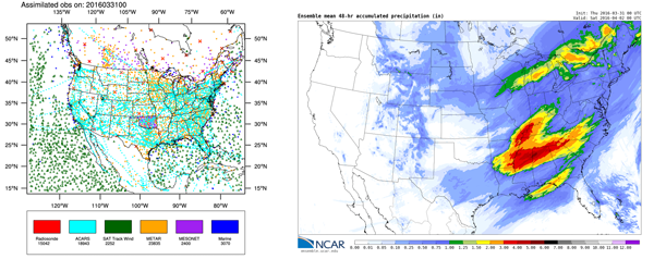
Scientists are using data assimilation techniques to input a range of North American observations into experimental, high-resolution U.S. forecasts. These real-time ensemble forecasts are publicly available while they're being tested. (@UCAR. This image is freely available for media & nonprofit use.)
Created by the NCAR Directorate, the Data Assimilation Program is designed to advance prediction of events ranging from severe weather and floods to air pollution outbreaks and peaks in the solar cycle.
One of its goals is to encourage collaborations among data assimilation experts at NCAR and the larger research community. For example, scientists in several labs are joining forces to apply data assimilation methods to satellite measurements to create a database of global winds and other atmospheric properties. This database will then be used for a broad range of climate and weather studies.
The program also provides funding to hire postdocs at NCAR to focus on data assimilation projects as well as for a software engineer to support such activities.

NCAR Senior Scientist Chris Snyder coordinates the Data Assimilation Program.
"By bringing money to the table, we’re building up data assimilation capability across NCAR,” said NCAR Senior Scientist Chris Snyder, who coordinates the Data Assimilation Program. “This is critical because data assimilation provides a framework to scientists throughout the atmospheric and related sciences who need to assess where the uncertainties are and how a given observation can help.”
NCAR Senior Scientist Jeff Anderson, who oversees the Data Assimilation Research Testbed (DART), says that data assimilation has become central for the geosciences. DART is a software environment that helps researchers develop data assimilation methods and observations with various computer models.
“I think the Data Assimilation Program is a huge win for NCAR and the entire atmospheric sciences community,” Anderson said. “The scientific method is about taking observations of the world and making sense of them, and data assimilation is fundamental for applying the scientific method to the geosciences as well as to other research areas.”
Here are examples of how data assimilation is advancing our understanding of atmospheric and related processes from ocean depths to the Sun’s interior:
Oceans. Karspeck is using data assimilation to estimate water properties and currents throughout the world's oceans. This is a computationally demanding task that requires feeding observations into the NCAR-based Community Earth System Model, simulating several days of ocean conditions on the Yellowstone supercomputer, and using those results to update the conditions in the model and run another simulation.
The good news: the resulting simulations match well with historical records, indicating that the data assimilation approach is working. “My goal is to turn this into a viable system for researchers,” Karspeck said.
Air quality. Atmospheric chemists at NCAR are using data assimilation of satellite observations to improve air quality models that currently draw on limited surface observations of pollutants. For example, assimilating satellite observations would show the effect of emissions from a wildfire in Montana on downwind air quality, such as in Chicago.
“We've done a lot of work to speed up the processing time and the results are promising," said NCAR scientist Helen Worden. “The model simulations after assimilating satellite carbon monoxide data are much closer to actual air quality conditions.”
Weather forecasting. Data assimilation is helping scientists diagnose problems with weather models. For example, why do models consistently overpredict or underpredict temperatures near the surface? Using data assimilation, NCAR scientist Josh Hacker discovered that models incorrectly simulate the transfer of heat from the ground into the atmosphere.
“With data assimilation, you’re repeatedly confronting the model with observations so you can very quickly see how things go wrong,” he said.
Solar cycle. Scientists believe the 11-year solar cycle is driven by mysterious processes deep below the Sun’s surface, such as the movements of cells of plasma between the Sun’s lower latitudes and poles. To understand the causes of the cycle and ultimately predict it, they are turning to data assimilation to augment observations of magnetic fields and plasma flow at the Sun’s surface and feed the resulting information into a computer model of subsurface processes.
“We are matching surface conditions to the model, such as the pattern and speed of the plasma flows and evolving magnetic fields,” said NCAR scientist Mausumi Dikpati.
Capturing data. In addition to helping scientists improve models, the new Data Assimilation Program is also fostering discussions about observations. NCAR senior scientist Wen-Chau Lee and colleagues who are experts in gathering observations are conferring with computer modelers over how to process the data for the models to readily ingest.
One challenge, for example, is that radars may take observations every 150 meters whereas the models often have a resolution of 1-3 kilometers. Inputting the radar observations into the models requires advanced quality control techniques, including coordinate transformation (modifying coordinates from observations to the models) and data thinning (reducing the density of observations while retaining the basic information).
“We are modifying our quality control procedures to make sure that the flow of data is smooth.” Lee said.
“With data assimilation, the first word is ‘data’,” he added. “Without data, without observations, there is no assimilation.”
Writer/contact
David Hosansky, Manager of Media Relations
Funders
NCAR Directorate
National Science Foundation
Additional funding agencies for specific projects