Arctic sea ice: The Great Recession continues
Aug 10, 2010 - by Staff
Aug 10, 2010 - by Staff
Bob Henson | 12 August 2010 • Just as the U.S. economy began a dramatic nosedive in 2007, so did the Arctic’s summertime sea ice. That September, the ice’s minimum seasonal extent shattered previous records. The minimums in 2008 and 2009 were somewhat less extreme, but still well below those observed in the 1980s and 1990s.
This summer, the ice—much like the economy—continues to struggle. “It’s pretty crazy that on 6 August we were already below the 1979–2000 average extent for September,” notes NCAR’s Jennifer Kay, a climate scientist focusing on processes that affect Arctic ice.

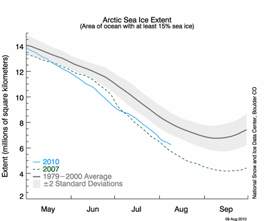
Arctic sea ice extent as of 9 August 2010. (Courtesy National Snow and Ice Data Center.)
The chart at right, from the National Snow and Ice Data Center (NSIDC), shows this summer’s melt compared to the 1979–2000 average and to the record melt of 2007 (current conditions here). As of late July, 5 of 17 participants in a monthly sea-ice prediction project were calling for the 2007 record to be broken or tied.
It’s now looking as if a new record is unlikely, according to Edward Blanchard (University of Washington), a specialist in Arctic ice prediction who is visiting NCAR this summer to collaborate with Kay. “It’s been a coolish August in the Arctic so far,” notes Blanchard. He points out that some large areas have already dipped below freezing (this map from the University of Köln shows current observations), and models are maintaining the chilly pattern for at least the next week to 10 days.
A graph from the International Arctic Research Center shows that 2010's ice extent is running closer to 2008 and 2009 than to 2007—still low, but not quite in record territory.
Weather is a critical determinant of Arctic sea ice evolution each summer. As Kay explained in Geophysical Research Letters, and with coauthor Andrew Gettelman in the Journal of Geophysical Research, the record midsummer melt in 2007 was enhanced by a persistent weather pattern: high pressure above Alaska and low pressure over northern Russia. High pressure leads to reduced cloud cover, which—especially if it occurs early in the melt season—allows more sunlight to reach the high Arctic surface. The strong high-to-low pressure gradient generates surface winds that bring warm air into the Arctic and can rearrange the existing ice in ways that foster ice-extent loss and melt—for example, by pushing ice through the central Arctic into the North Atlantic, where it ends up melting.
This year, the ice melted quickly in late June, but the pace slowed in early July, as low-pressure centers moving across the Arctic brought clouds and coolness and spread sea ice over a larger area (as explained by NSIDC in its 20 July news post). Short-term weather shifts like this can’t be predicted more than a few days in advance, which makes it tough to know in early July where sea ice will be in September. But by August, the die is largely cast, says Blanchard: the Sun’s rays are dimming, and the persistence in sea-ice anomalies from August to September is the largest of any two months of the year.
Even now, a windy period could help break up thinner, more diffuse areas of ice and accelerate the retreat, says Blanchard. However, he adds, “I would put my money rather confidently at this stage on not breaking the record.”
You can follow the Arctic’s summer melting live on camera—at least from one vantage point—via NOAA’s North Pole webcam. It’s placed atop a buoy near the North Pole each April and floats with the ice through the summer. Right now the buoy is near 85°N and 10°E. “It’s instructive to compare images from now with those from previous summers around the same date,” Blanchard says. For instance, during the record melt of 2007, the webcam showed large sections of open water. On the most recent image from this year, melt ponds are already freezing. (See below for a side-by-side comparison.)
Predicting the Arctic’s minimum sea ice extent may become still more difficult in years to come, as multiyear ice continues to erode. “In contrast to the much thicker ice of past decades, the ice now reacts very quickly and very sensitively to the weather patterns that are predominant during a certain summer,” notes Dirk Notz (Max Planck Institute for Meteorology) in a RealClimate post on 26 July.

NOAA's webcam in the high Arctic shows more open water on 10 August 2007 (left) than on 12 August 2010. (Images courtesy NOAA's Arctic Theme Page.)