Lifesaving storm warnings for Africa's Lake Victoria
NCAR works to improve forecasts for fishers, boaters
Oct 18, 2019 - by David Hosansky
Early closure on July 3 and 4 - NSF NCAR Road, Parking Lot and Trails
View more information.Oct 18, 2019 - by David Hosansky
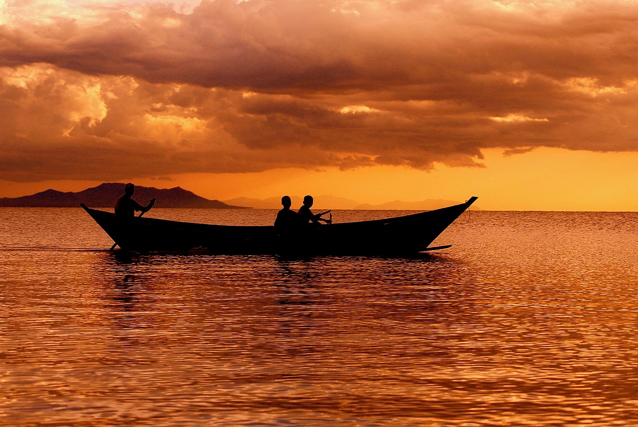
Fishermen at dusk on Lake Victoria. NCAR is taking part in an international effort to improve weather forecasts and disseminate warnings to protect fishers and boaters on the lake. (Image: Wikipedia/Africraigs.)
Lake Victoria has a well-deserved reputation for dangerous weather patterns, with severe thunderstorms and strong winds forming rapidly at night. These take a tragic toll across a large region of East Africa: an estimated 3,000-5,000 fishers and small boat operators die on the lake every year, often unaware when dangerous storms are approaching.
To improve safety on Africa's largest lake, the National Center for Atmospheric Research (NCAR) is taking part in a three-year, international effort to develop a detailed marine forecasting system. The HIGH impact Weather Lake System project (HIGHWAY) aims to increase the use of weather information, helping the nations in the Lake Victoria Basin to disseminate timely forecasts and warnings to those who may be at risk.
In addition to saving lives, the project has significant economic ramifications: Lake Victoria, which borders Kenya, Tanzania, and Uganda, produces more than $600 million worth of fish each year. An estimated 35 million people, including those in the downstream countries of Burundi and Rwanda, depend directly or indirectly on the fishery.
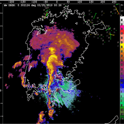
NCAR's role in HIGHWAY includes leading a field campaign this year to help determine how nighttime thunderstorms form and develop over the lake. Scientists are taking measurements from numerous observing instruments, including ground-based radars, balloon-borne radiosondes, and buoys on the lake itself in an effort to develop an effective early warning system for high-impact weather events over the water.
NCAR researchers are also involved in training local forecasters on the use of radars and other short-term weather prediction tools.
"I find it very exciting to work with the local forecasters because they really want to make sure they understand how to use the radar, satellite and lightning data and their other observations as effectively as possible," said NCAR scientist Rita Roberts, a principal investigator on HIGHWAY. "This is the best kind of project because you feel like you're helping to move things forward and making a difference to society."
HIGHWAY is managed by the World Meteorological Organization and funded by the U.K. Department for International Development. Partners include the National Meteorological and Hydrological Services of Kenya, Rwanda, Tanzania, Uganda, and the United Kingdom. The international team of meteorologists working on the project are collaborating with experts in other disciplines, including social scientists, to study potential risks and vulnerabilities in the Lake Victoria Basin, coordinate early warning systems, and work toward better communication of hazards to vulnerable communities.
The intensive international effort is part of a 10-year project by the World Weather Research Programme called HIWeather that focuses on improving early warning systems in much of the world and protecting lives and livelihoods.
The Lake Victoria Basin is affected by an unusually high number of thunderstorms, a result of abundant moisture and intense sunshine that creates atmospheric instabilities and fuels heavy rains. Storms develop around the lake during the day as relatively cool lake breezes clash with warm air over the land; then at night the opposite situation occurs as relatively cool land breezes clash with warm air over the lake.
The situation is particularly perilous for fishers, as the fishing tends to be best at night in the same regions where thunderstorm outflows generate high waves.
“As fishermen, the problem that we face is that we encounter strong winds, fog, heavy clouds and water spouts," Joseph Omer a fisher in Jinja, Uganda, told the World Meteorological Organization. "They just show up unexpectedly, making it difficult for us to do our work well. We are struggling.”
Until now, those venturing out on the lake have lacked reliable weather forecasts. But the situation is changing as a result of HIGHWAY, with the fishing community starting to get twice-daily forecasts. These are communicated in various ways, including being disseminated directly to village chiefs, as well as via local radio stations and cellphones.
Scientists with HIGHWAY will study data gathered during the current field campaign to learn more about the factors that spawn storms over the lake with the goal of better forecasting them.
With advanced Doppler radars being installed in the Lake Victoria region, Roberts and NCAR scientist Jim Wilson are training local meteorological agencies to interpret radar images of complex and sometimes rapidly evolving conditions. The goal is to increase the accuracy and timeliness of short-term weather predictions, including nowcasts, through such techniques as animating radar images and extrapolating where storms are headed based on current conditions. They're also sharing best practices for quality control of, and archiving, radar data.
Researchers with NCAR's managing entity, the University Corporation for Atmospheric Research, are also installing a network of low-cost, 3D-Printed Automatic Weather Stations in the Lake Victoria Basin. NCAR is providing logistical support for HIGHWAY, including posting online displays of field campaign observations and archiving data from the campaign.
In addition, NCAR is providing training for Tanzanian meteorologists on the NCAR-based Weather and Research Forecasting (WRF) model. Used by meteorologists around the world, WRF can be applied for short-term predictions of weather across the Lake Victoria Basin.
Although the focus is on improving forecasts and warnings, the HIGHWAY project is leading to new insights into the weather. For example, the multitudes of insects over the lake act as a sort of tracer in the lower atmosphere, creating backscatter echoes on radar that reveal the movement of low-level winds and the convergence lines where the winds come together at the leading edge of thunderstorm outflows.
Wilson, a 40-year veteran of radar meteorology, said that such boundaries had never previously been observed over large bodies of water like Lake Victoria.
"This is about both learning more about interesting weather and doing good for humanity," he said. "You can't beat that."