After 14 years, first COSMIC satellite mission comes to an end
The pioneering constellation of small satellites improved weather forecasts and advanced atmospheric science using the “GPS radio occultation” technique
May 28, 2020 - by Laura Snider
Early closure on July 3 and 4 - NSF NCAR Road, Parking Lot and Trails
View more information.May 28, 2020 - by Laura Snider
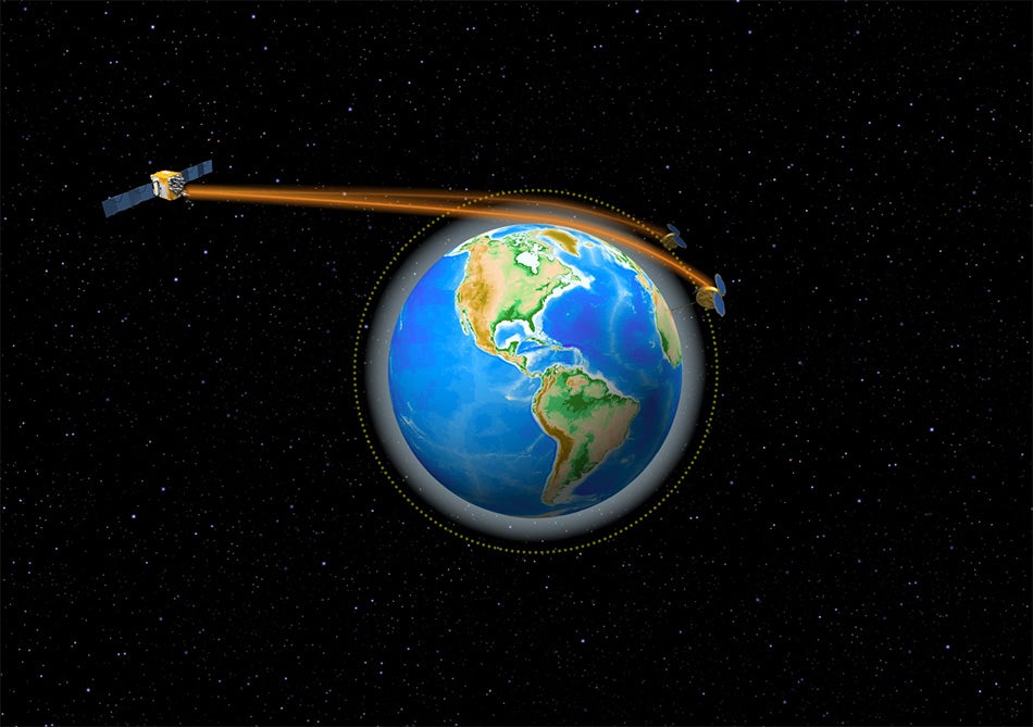
The COSMIC satellites produced vertical profiles of the atmosphere by measuring the bend of GPS radio signals as they traveled through the atmosphere. (Image: Simmi Sinha, UCAR)
The last of six tiny satellites that were rocketed into space 14 years ago – and then went on to prove that the wealth of accurate atmospheric data that can be gleaned from existing GPS signals can improve operational weather forecasts – was officially decommissioned on May 1, outliving its original planned lifespan by a dozen years.
The first Constellation Observing System for Meteorology, Ionosphere, and Climate (COSMIC) mission, launched in 2006, used a technique known as radio occultation to derive vertical atmospheric profiles of temperature, humidity, and pressure by measuring the degree to which GPS signals bend as they travel through Earth’s atmosphere. The resulting flood of high-quality, extremely accurate data was provided to weather centers to improve forecasts and to research institutions for use in scientific studies.
Throughout its lifetime, COSMIC-1 made an astounding 7 million vertical atmospheric profiles available to the operational forecast centers and research community. These data demonstrably boosted forecast accuracy and were referenced in more than 550 peer-reviewed scientific publications. In all, more than 5,000 users from over 100 countries have accessed COSMIC data.
The COSMIC Program and its data products are managed by the University Corporation for Atmospheric Research (UCAR). COSMIC-1 was primarily funded by the National Space Organization in Taiwan, where the mission is called FORMOSAT-3. The leading U.S. sponsor on the project was the National Science Foundation, and other U.S. partners included the NASA, National Oceanic and Atmospheric Administration (NOAA), the Air Force, and the Office of Naval Research.
“COSMIC-1 showed the world that these compact, low-cost satellites could have a big impact on our ability to accurately predict the weather and better understand atmospheric processes,” said Bill Schreiner, director of the UCAR COSMIC program.
COSMIC-1 inspired entities in both the government and private sectors to pursue more and better-quality Global Navigation Satellite System (GNSS) radio occultation data. Among the new missions inspired by COSMIC’s success is its own follow-on, COSMIC-2 (FORMOSAT-7), another successful partnership between the United States and Taiwan. The mission was launched last year by NOAA as their first operational GNSS radio occultation mission.
COSMIC-2 is now producing more than 4,000 high-quality atmospheric profiles daily that are being made available for numerical weather prediction operations and to scientists for research studies. COSMIC-1 also inspired the commercial industry to collect radio occultation data, which has led NOAA and other U.S. agencies to purchase such data for evaluation and for possible operational and scientific use.
“The first COSMIC mission was a remarkable success both operationally and scientifically. It helped establish GNSS radio occultation data as a core component of our Earth observing system, and it helped inspire new radio occultation missions that are sure to benefit society for years to come,” Schreiner said. “After 14 years, we send our thanks and fondest farewell to the COSMIC-1 satellites, but they won’t be forgotten, especially when we regularly reprocess their data for future use.”
History of COSMIC-1: https://news.ucar.edu/19848/cosmic-turns-10-microsatellites-reveal-atmospheric-properties-3d
Data available from COSMIC-2: https://news.ucar.edu/132710/newly-released-satellite-data-poised-significantly-improve-weather-forecasts
Launch of COSMIC-2: https://news.ucar.edu/132670/cosmic-2-atmospheric-observing-system-slat…