Scientists focus on Lahaina Fire to improve prediction of wildland-urban fires
Research may help with firefighting, evacuations
Feb 20, 2024 - by David Hosansky
Feb 20, 2024 - by David Hosansky
| Impact statement: New modeling tool could lay the groundwork for more detailed predictions of wildfires that advance into towns and cities, eventually helping with firefighting efforts and safer evacuations as well as the design of wildfire-resistant communities. |
Scientists have successfully applied a pair of advanced computer models to simulate last year’s wildfire that devastated the Hawaiian town of Lahaina. The development could lay the groundwork for more detailed predictions of wildfires that advance into towns and cities, eventually helping with firefighting efforts and safer evacuations as well as the design of wildfire-resistant communities.
The study, led by the U.S. National Science Foundation National Center for Atmospheric Research (NSF NCAR), brought together a cross-disciplinary team of meteorologists with structural and environmental engineers. Their combined expertise enabled them to simulate how intense winds whipped up a brushfire and drove the flames in various directions through neighborhoods and commercial districts, igniting and destroying a variety of structures amid chaotic evacuations.
Although scientists for years have worked to improve predictions of fires that burn through forests and grasslands in various terrains, they have only recently turned to the even more difficult challenge of predicting how a fire will behave once it encounters populated areas. Such events have become more frequent in the past decade, often with tragic consequences.
“It’s such a complex situation when fires move from outlying areas into a town, but this study shows that we’ll have the capability in the not-too-distant future to predict fire spread within minutes of knowing the location and timing of fire ignition,” said NSF NCAR scientist Timothy Juliano, the lead author of the new study. “Our approach can serve as a basis going forward to understanding how extreme weather conditions can affect fire behavior in various types of built environments and ultimately better protect vulnerable communities.”
Juliano himself witnessed the need for improved prediction when he had to evacuate his house in Louisville, Colorado, during the 2021 Marshall Fire that destroyed more than 1,000 structures.
The research team included experts from the University of Buffalo, the University of Nevada Reno, and the Cooperative Institute for Research in Environmental Sciences at the University of Colorado Boulder. The study, funded by NSF, was published in Natural Hazards and Earth System Sciences, a journal of the European Geosciences Union.
Fast-moving wildfires in recent years have devastated communities in such far-flung locations as Superior and Louisville, Colorado; Talent and Phoenix, Oregon; Paradise, California; and Gatlinburg and Pigeon Forge, Tennessee. The Lahaina Fire of August 8-9, 2023, was especially tragic, killing 100 people and destroying more than 2,200 structures. It was the deadliest U.S. fire in more than a century.
In each of these cases, the flames swept from vegetated areas into subdivisions and strip malls during extreme wind events, overwhelming firefighting efforts and inflicting major damage within 12 hours of ignition. Scientists are working to better understand such events, which require painstaking analysis of local atmospheric conditions as well as a determination of how a fire can blaze through woodlands or grasslands and then, once in town, ignite one structure after another.
To gain a detailed picture of the Lahaina Fire, the research team paired two computer models with different capabilities.
One, the NSF NCAR–based Weather Research and Forecasting (WRF) model, was used to simulate the downslope windstorm that erupted on the day of the fire, generating gusts up to 80 miles per hour. The high-resolution model could show the turbulent wind flows around Lahaina and a “hydraulic jump” — an event in which winds rushing downhill abruptly rise when they collide with winds flowing in the other direction, setting off chaotic and powerful motions of air.
The wind fields from the WRF simulation were fed into the second model, Streamlined Wildland-Urban Interface Fire Tracing (SWUIFT). This model can simulate the spread of flames in a developed area, capturing the ways that extreme heat and shooting embers can set structures ablaze.
The simulations captured strong winds on the morning of August 8 flowing down the mountainous slopes of Pu'u Kukui east of Lahaina. These winds encountered a reverse flow, creating a hydraulic jump that would gradually move offshore.
By mid-afternoon, the strongest winds were buffeting areas just east of downtown Lahaina, where the fire is believed to have started in dry grass. In the early evening, the hydraulic jump began to move back to the east toward Lahaina and then partially up the slope of Pu'u Kukui. This enveloped the city in especially treacherous wind fields, known as turbulent rotors, with mean winds reversing and flowing from the west to east in contrast with the earlier strong flow of east to west during the ignition.
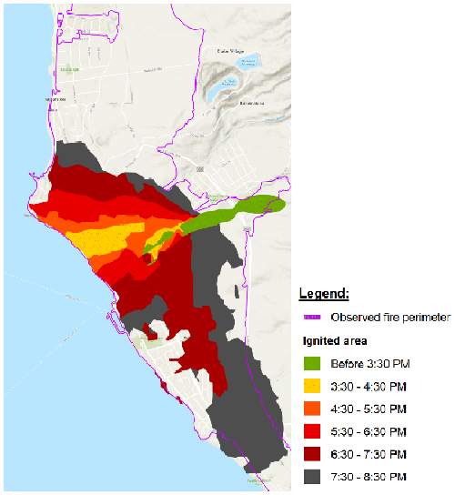
The changes in wind direction proved fateful. The simulation showed that the initial fire spread from about 3:30-4:30 p.m., moving from vegetation to structures in a narrow path in the same direction as the wind and reaching historic areas by the oceanfront. The fire front then slowly widened and, beginning around 7:30 p.m., accelerated as the change in winds drove the flames in all directions, reaching structures in the southern portion of Lahaina while also continuing to expand northward.
“The subsequent, and rather abrupt, shift in the winds to onshore (westerly) and extreme variability was particularly insidious in that it allowed continued fire spread in all directions, and thus, those fleeing the initial east-to-west run did not have a safe haven apart from the ocean,” the paper states. “In other words, it was not a simple situation of moving out of the path of the fire.”
The results from the simulation generally tracked well with witness reports and recorded videos for the fire spread.
The authors noted that, in addition to the unusually strong and turbulent wind fields, multiple factors affected the death toll. They said further research is needed into the role of building construction types, evacuation planning and orders, blocked egress, and population demographics (many of the fire’s victims were elderly).
Still, even in such a complex situation, Juliano and his co-authors concluded that advanced computer modeling can make a difference when a community is threatened by a fast-moving fire. Their research shows it should be possible to develop new technologies that can run computer simulations in faster than real time to help with firefighting and evacuations. Such technologies can also help guide planning to reduce fire risk long before a conflagration ignites.
“I was surprised by how well the simulation came out,” Juliano said. “This study demonstrates the potential to develop an active-fire decision support system that can revolutionize the response to fires in the built environment and empower a future in which society coexists with wildfires.”